Historic Sites and Points of Interest in Siskiyou County
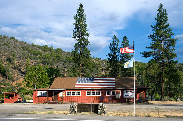
 Klamath River Community Hall on State Route 96
13 September 2010
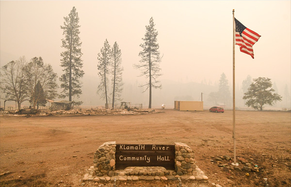
 Klamath River Community Hall was destroyed by the McKinney Wildfire on 29 July 2022
Photograph ©2022 Grants Pass Daily Courier, used with permission
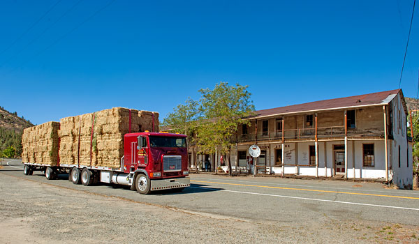
 State Route 3 in the Town of Callahan
15 September 2014
 Old Stage Road Near Mount Shasta City
29 April 2010
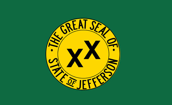
 Flag of the State of Jefferson
The two x's signify double crossed
Source Wikipedia Commons
(Click Photos to Enlarge)
The origin of the word Siskiyou is uncertain. It may be derived from the Chinook word for a bob-tailed horse or from the French phrase six cailloux (six stones in English).
In 2010, the population of the county was 44,900. Only one town, Yreka, has a population greater than 5,000.
1941, Gilbert Gable, the mayor of Port Orford, Oregon, proposed that the counties of northern California and southern Oregon secede from their respective states and form a new state, the State of Jefferson. Gale felt that the region was too from the state capitals in Salem (Oregon) and Sacramento (Califonia) and was poorly understood and served by legislators and bureaucrats.
The secessionist notion survived over the years, sometimes in jest, sometimes in earnest.
In the late 1990s, the Klamath water war galvanized local property-rights proponents. The now-legendary conflict fueled residents’ feeling that the region was a place apart, misrepresented by urban lawmakers who threatened a way of life with their environmental regulations and bureaucratic ineptitude. [High County News, 13 November 2006]
The State of Jefferson, at its most ambitious, includes twelve California counties (Butte, Del Norte, Humboldt, Glenn, Lassen, Mendocino, Modoc, Plumas, Shasta, Siskiyou, Tehama and Trinity) and seven Oregon counties (Coos, Curry, Douglas, Jackson, Josephine, Klamath and Lake).
Siskiyou County has always been the heart of the State of Jefferson. On September 3, 2013, the County Board of Supervisors voted four to one in favor of secession from California.
| Name | Address | City | Year | Authority | ID | Sort Address | Sort Name |
|---|---|---|---|---|---|---|---|
| Captain Jack's Stronghold | Captain Jacks Stronghold Trail | Lava Beds National Monument | 1872 | California | 9 | Captain | Captain Jack's Stronghold |
| Guillem's Graveyard | Hill Road | Lava Beds National Monument | 1872 | California | 13 | Hill 1 | Guillem's Graveyard |
| Canby's Cross | Monument Road | Lava Beds National Monument | 1873 | California | 110 | Monument 1 | Canby's Cross |
| Fort Jones Site | Route 3 | Fort Jones | 1852 | California | 317 | Route 003 | Fort Jones Site |
| Strawberry Valley Stage Station | North Old Stage Road | Mt Shasta | 1857 | California | 396 | Old Stage 1 | Strawberry Valley Stage Station |
| Emigrant Trail | Route 97 and Military Pass Road | Weed | 1857 | California | 517 | Route 097 | Emigrant Trail |
| Yreka | West Miner Sreet and Broadway | Yreka | 1851 | California | 901 | Miner W 100 | Yreka |
| Lower Klamath National Wildlife Refuge | 4009 Hill Road | Lower Klamath National Wildlife Refuge | 1908 | National | 1966000238 | Hill | Lower Klamath National Wildlife Refuge |
| West Miner Street Historic District | 102 West Miner Street and 122-419 3rd Street | Yreka | 1855 | National | 1972000258 | Miner W 102 | West Miner Street Historic District |
| Hospital Rock Army Camp Site | Monument Road East of Lyons Road | Lava Beds National Monument | 1873 | National | 1973000227 | Monument 3 | Hospital Rock Army Camp Site |
| Captain Jack's Stronghold | Captain Jacks Stronghold Trail | Lava Beds National Monument | 1872 | National | 1973000259 | Captain | Captain Jack's Stronghold |
| Fort Jones House | Main Street | Fort Jones | 1851 | National | 1976000533 | Main | Fort Jones House |
| Thomas-Wright Battle Site | Thomas-Wright Battlefield Trail | Lava Beds National Monument | National | 1978000366 | Hill 2 | Thomas-Wright Battle Site | |
| Sawyers Bar Catholic Church | Sawyers Bar Road | Sawyers Bar | 1855 | National | 1978000792 | Sawyers | Sawyers Bar Catholic Church |
| White's Gulch Arrastra | Klamath National Forest | Sawyers Bar | National | 1978000793 | Klamath National Forest | White's Gulch Arrastra | |
| Falkenstein House | 401 South Gold Street | Yreka | 1855 | National | 1979000554 | Gold 401 | Falkenstein House |
| Shasta Inn and Weed Lumber Company Boarding House | 829 and 877 North Davis Avenue | Weed | 1901 | National | 1980000869 | Davis 829 | Shasta Inn and Weed Lumber Company Boarding House |
| Dunsmuir Historic District | Bounded by Sacramento, Shasta, Spruce, Cedar | Dunsmuir | 1890 | National | 1982000993 | Sacramento | Dunsmuir Historic District |
| Hotel Macdoel | Montezuma Avenue and Mt. Shasta Street | Macdoel | 1906 | National | 1982002275 | Mt. Shasta | Hotel Macdoel |
| McCloud Historic District | Bounded by Main, Columbero, West Minnesota, and Lawndale | McCloud | 1896 | National | 1990000444 | Main | McCloud Historic District |
| Harlow Cabin | 1050 Elliott Creek Road | Joe Bar | 1930 | National | 1991000699 | Elliott Creek 1050 | Harlow Cabin |
| Yreka Carnegie Library | 412 West Miner Street | Yreka | 1915 | National | 1992000270 | Miner W 412 | Yreka Carnegie Library |
| Edgewood Store | 24505 Edgewood Road | Edgewood | 1888 | National | 2004000140 | Edgewood 24505 | Edgewood Store |
| Forest House | 4204 California State Route 3 | Yreka | National | 2011000433 | Route 003 | Forest House | |
| Schonchin Butte Fire Lookout | Schonchin Butte Road | Lava Beds National Monument | National | 2017001559 | Schonchin Butte | Schonchin Butte Fire Lookout | |
| Camp Tulelake | Hill Road | Tulelake | National | 2018002176 | Hill Road | Camp Tulelake | |
| Ager Stage Stop | Ager Beswick Road at Hornbrook Ager Road | Ager | 1887 | POI | Ager | Ager Stage Stop | |
| Applegate Trail 46 | Dorris Brownell Road | Applegate Trail | POI | Dorris | Applegate Trail 46 | ||
| Applegate Trail 47 | Dorris Brownell Road | Applegate Trail | POI | Dorris | Applegate Trail 47 | ||
| Applegate Trail 48 | Lower Klamath Road | Applegate Trail | POI | Lower Klamath | Applegate Trail 48 | ||
| Applegate Trail 49 | Dorris Brownell Road | Applegate Trail | POI | Dorris | Applegate Trail 49 | ||
| Applegate Trail 50 and Yreka Trail 1 | Dorris Brownell Road (4WD) | Applegate Trail | POI | Dorris | Applegate Trail 50 and Yreka Trail 1 | ||
| Applegate Trail 51 | Wilow Creek Road | Applegate Trail | POI | Willow Creek | Applegate Trail 51 | ||
| Applegate Trail 52: South Road - Hot Creek | Dorris Brownell Road | Applegate Trail | 1846 | POI | Dorris | Applegate Trail 52: South Road - Hot Creek | |
| Babe Ruth Played Here | 4841 Dunsmuir Avenue | Dunsmuir | POI | Dunsmuir 4841 | Babe Ruth Played Here | ||
| Berryvale Post Office | South Old Stage Road | Mt Shasta | 1870 | POI | Old Stage 2 | Berryvale Post Office | |
| Bradford Ripley Alden | Copco Road | Hornbrook | 1853 | POI | Copco | Bradford Ripley Alden | |
| Brown-Nickell-Authenrieth Building | 322 and 324 West Miner Street | Yreka | 1856 | POI | Miner W 0322 | Brown-Nickell-Authenrieth Building | |
| Church of Saints John and Paul | 200 East Fork Road | Callahan | 1858 | POI | East Fork | Church of Saints John and Paul | |
| Cottonwood Basin | Copco Road | Hornbrook | 1851 | POI | Copco | Cottonwood Basin | |
| Cottonwood Stage Coach Station | Oregon Road | Hornbrook | 1854 | POI | Oregon | Cottonwood Stage Coach Station | |
| Crystal Creek Methodist Church Site | State Route 3 | Etna | POI | 003-30 | Crystal Creek Methodist Church Site | ||
| Deadwood | Deadwood Creek Road | Klamath National Forest | POI | Deadwood | Deadwood | ||
| Dry Gulch Bridge | State Route 263 | Dry Gulch | POI | 263-50 | Dry Gulch Bridge | ||
| Dunsmuir Fountain | Dunsmuir City Park | Dunsmuir | POI | Dunsmuir 4841 | Dunsmuir Fountain | ||
| Farrington Blacksmith Shop | 12530 State Route 3 | Callahan | POI | 003-80 | Farrington Blacksmith Shop | ||
| Frogtown | SR 263 Near Long Gulch Road | Hawkinsville | POI | 263 | Frogtown | ||
| Greenhorn | Greenhorn Park | Yreka | POI | Greenhorn | Greenhorn | ||
| Gus Meamber Pack Train Trail | 9317 Scott River Road | Fort Jones | POI | Scott River 9317 | Gus Meamber Pack Train Trail | ||
| Hayden Hotel | State Route 3 | Callahan | POI | 003-85 | Hayden Hotel | ||
| Horse Creek Road Bridge Over the Klamath River | Horse Creek Road at Route 96 | Klamath National Forest | POI | Route 096 | Horse Creek Road Bridge Over the Klamath River | ||
| IOOF: Etna | Collier Way at Pig Alley | Etna | POI | Collier | IOOF: Etna | ||
| IOOF: Yreka | 107-117 West Miner Street | Yreka | POI | Miner W 0107 | IOOF: Yreka | ||
| Jefferson Davis | Copco Road | Hornbrook | POI | Copco | Jefferson Davis | ||
| Klamathon | Klamathon Road near Ager Road | Hornbrook | POI | Klamathon | Klamathon | ||
| Locomotive 1727 | 4841 Dunsmuir Avenue | Dunsmuir | POI | Dunsmuir 4841 | Locomotive 1727 | ||
| Masonic Hall | 11819 Main Street | Fort Jones | POI | Main 11819 | Masonic Hall | ||
| McBride Ranch | 2300 East Callahan Road | Etna | POI | Callahan East 2300 | McBride Ranch | ||
| Meamber School | 7044 Scott River Road | Fort Jones | POI | Scott River 7044 | Meamber School | ||
| Montague | 146 South 11th Street | Montague | POI | Street 011 S 146 | Montague | ||
| Montague Depot Museum | 230 South 11th Street | Montague | POI | Street 011 S 230 | Montague Depot Museum | ||
| Moonlit Oaks Dance pavilion | 150 Moonlit Oaks Avenue | Yreka | POI | Moonlit | Moonlit Oaks Dance pavilion | ||
| No. 4 Kingpin Hydraulic Giant | 910 South Main Street | Yreka | POI | Main S 0910 | No. 4 Kingpin Hydraulic Giant | ||
| Robbers Rock | State Route 3 Near Soap Creek Ridge Road | Rural | POI | 003-10 | Robbers Rock | ||
| Sacred Heart Catholic Church | 11630 Main Street | Fort Jones | POI | Main 11630 | Sacred Heart Catholic Church | ||
| Sawyers Bar | Sawyers Bar Road | Sawyers Bar | POI | Sawyers | Sawyers Bar | ||
| Scott River Bridge | State Route 3 | Callahan | POI | 003-70 | Scott River Bridge | ||
| Siskiyou County Museum | 910 South Main Street | Yreka | 1950 | POI | Main S 910 | Siskiyou County Museum | |
| Sisson Museum | 1 North Old Stage Road | Mt Shasta | POI | Old Stage 1 | Sisson Museum | ||
| Smith and Rosenburg Building | 219-223 West Miner Street | Yreka | POI | Miner W 0219 | Smith and Rosenburg Building | ||
| Sullaway Stage Stop | 1208 Old Stage Road | Mt Shasta | POI | Old Stage 1208 | Sullaway Stage Stop | ||
| Tacitus Ryland Arbuckle | 8020 East Callahan Road | Etna | POI | Callahan East 8020 | Tacitus Ryland Arbuckle | ||
| Thompson’s Dry Diggings | Yama Street near Discovery Street | Yreka | POI | Yama 1000 | Thompson’s Dry Diggings | ||
| Tule Lake Unit of WWII Valor in the Pacific National Monument | 800 Main Street | Tulelake | POI | Main 0800 | Tule Lake Unit of WWII Valor in the Pacific National Monument | ||
| Weed Arch | Main Street and South Weed Boulevard | Weed | POI | Main | Weed Arch | ||
| Weed Historic Lumber Town Museum | 303 Gilman Avenue | Weed | POI | Gilman 303 | Weed Historic Lumber Town Museum | ||
| Witherill Building | 331 and 333 West Miner Street | Yreka | POI | Miner W 0331 | Witherill Building | ||
| Yreka Historic Trail | Tenant Road | Yreka Trail | POI | Tenant | Yreka Historic Trail | ||
| Yreka Trail 1 and Applegate Trail 50 | Dorris Brownell Road (4WD) | Yreka Trail | POI | Dorris | Yreka Trail 1 and Applegate Trail 50 | ||
| Yreka Trail 2 | Willow Creek Red Rock Road | Yreka Trail | POI | Willow | Yreka Trail 2 | ||
| Yreka Trail 3 | Willow Creek Red Rock Road | Yreka Trail | POI | Willow | Yreka Trail 3 | ||
| Yreka Trail 4 | Red Rock Road | Yreka Trail | POI | Red Rock | Yreka Trail 4 | ||
| Yreka Trail 5 | Off Red Rock Road | Yreka Trail | POI | Red Rock | Yreka Trail 5 | ||
| Yreka Trail 6 | Old Sate Highway | Yreka Trail | POI | Old State | Yreka Trail 6 | ||
| Yreka Trail 6A | Off Old Sate Highway | Yreka Trail | POI | Old State | Yreka Trail 6A | ||
| Yreka Trail 6B | Off Old Sate Highway | Yreka Trail | POI | Old State | Yreka Trail 6B | ||
| Yreka Trail 7 | Off Old Sate Highway | Yreka Trail | POI | Old State | Yreka Trail 7 | ||
| Yreka Trail 8 | Forest Service Road 44N30X | Yreka Trail | POI | FS044 | Yreka Trail 8 | ||
| Yreka Trail 9: Are Yet On Butte Creek | Tennant Road | Yreka Trail | POI | Tennant | Yreka Trail 9: Are Yet On Butte Creek | ||
| Yreka Trail 10: Splendid Pine Timber | Forest Service Road 44N18Y | Yreka Trail | POI | FS044 | Yreka Trail 10: Splendid Pine Timber | ||
| Yreka Trail 11: A Big Meadow | State Route 97 | Yreka Trail | POI | Route 097 | Yreka Trail 11: A Big Meadow | ||
| Yreka Trail 12: A Splendid Cite | State Route 97 | Yreka Trail | POI | Route 097 | Yreka Trail 12: A Splendid Cite | ||
| Yreka Trail 13: Sheep Rock | State Route 97 | Yreka Trail | POI | Route 097 | Yreka Trail 13: Sheep Rock | ||
| Yreka Trail 14: Sheep Rock Springs | Pilar Road at Perla Drive | Yreka Trail | POI | Pilar | Yreka Trail 14: Sheep Rock Springs | ||
| Yreka Trail 15: The Snelling Ranch | Harry Cash Road | Yreka Trail | POI | Harry Cash | Yreka Trail 15: The Snelling Ranch | ||
| Yreka Trail 16: Down Shasta Valley | Harry Cash Road | Yreka Trail | POI | Harry Cash | Yreka Trail 16: Down Shasta Valley | ||
| Yreka Trail 17 | Big Springs Road | Yreka Trail | POI | Big Springs | Yreka Trail 17 | ||
| Yreka Trail 18 | County Road A28 | Yreka Trail | POI | A28 | Yreka Trail 18 | ||
| Yreka Trail 19 | Campbell Avenue | Yreka Trail | POI | Campbell | Yreka Trail 19 | ||
| Yreka Trail 20: A Mighty Town | 850 Yama Street | Yreka Trail | POI | Yama 0850 | Yreka Trail 20: A Mighty Town | ||
| Yreka Western Railroad | South Foothill Drive at East Center Street | Yreka | POI | Foothill | Yreka Western Railroad |