National Register of Historic Places in Monterey County
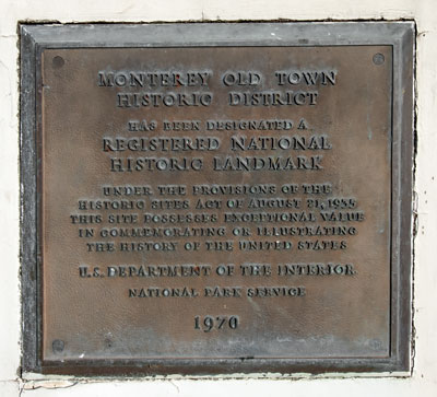
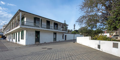
 The marker, visible at the lower right in the photograph, is mounted on a retaining wall near the
Old Pacific House.
9 December 2018
(Click Photos to Zoom)
Monterey Old Town Historic District
Monterey
From 1770 until 1849, Monterey was the stronghold of European civilization on the American Pacific Coast and the hub of social, economic and political activities in Alta California.
Founded on 3 June 1770, Monterey was the second of the four presidios established by the Spanish in California. (The other presidios founded by Spain were San Diego, Santa Barbara and San Francisco. The Sonoma Presidio was built when Alta California was ruled by Mexico.)
Early in the 1820s, the inhabitants began to construct their houses outside the adobe walls of the fort and Monterey was formally authorized as a pueblo by the Mexican government in 1827. By 1830, the population was about five hundred. In 1845, it was about seven hundred and fifty. Old Monterey was then a tangle of narrow streets irregularly laid out, and its some two hundred buildings were widely scattered.
In the 20th century, Monterey expanded, demolished and rebuilt, until only a few dozen of the 19th century historic structures remained. Many are widely scattered with the former open areas between them now occupied by modern structures that impair the historic scene.
Two pockets of historic structures have survived.
The southern section is bounded roughly by the four blocks surrounding the intersection of Madison and Pacific Streets.
The northern section borders on the bay and includes the blocks surrounding the intersections of Scott, Pacific, Olivier, Calle Principal and Alvarado Streets.
Monterey Old Town Historic District is a National Historic Landmark.
Source: Adapted from the NRHP nomination submitted in 1970.
| Name | Year | Address | Remarks | Sort Address | Sort Name |
|---|---|---|---|---|---|
| Alvarado Adobe | 1830 | 570 Dutra Street | Southern Section | Dutra 0570 | Alvarado Adobe |
| Alvarado House | 1836 | 494-498 Alvarado Street | Southern Section | Alvarado 0494 | Alvarado House |
| Casa Amesti | 1834 | 516 Polk Street | Southern Section | Polk 0516 | Casa Amesti |
| Casa de la Torre | 1852 | 502 Pierce Street | Southern Section | Pierce 0502 | Casa de la Torre |
| Casa del Oro | 1845 | Olivier and Scott Streets | Northern Section | Olivier Scott | Casa del Oro |
| Colton Hall | 1847 | Pacific Street Between Jefferson and Madison | Southern Section | Pacific | Colton Hall |
| Cooper-Molera Adobe | 1829 | 525 Polk Street | Southern Section | Polk 0525 | Cooper-Molera Adobe |
| First Brick House | 1847 | 351 Decatur Street | Northern Section | Decatur 0351 | First Brick House |
| First Federal Courthouse | 1836 | 599 Polk Street | Southern Section | Polk 0599 | First Federal Courthouse |
| First Theater in California | 1846 | Pacific and Scott Streets | Northern Section | Pacific Scott | First Theater in California |
| General Sherman Quarters | 1834 | 464 Calle Principal | Southern Section | Calle Principal 0464 | General Sherman Quarters |
| Gordon House | 1849 | 527 Pierce Street | Southern Section | Pierce 0527 | Gordon House |
| Gutiérrez Adobe | 1841 | 590 Calle Principal | Southern Section | Calle Principal 0590 | Gutiérrez Adobe |
| House of Four Winds | 1835 | 540 Calle Principal | Southern Section | Calle Principal 0540 | House of Four Winds |
| Larkin House | 1837 | 500 Calle Principale | Southern Section | Calle Principale 0500 | Larkin House |
| Old Custom House | 1827 | Custom House Plaza | Northern Section | Custom House Plaza | Old Custom House |
| Old Pacific House | 1847 | Custom House Plaza | Northern Section | Custom House Plaza | Old Pacific House |
| Old Whaling Station | 1855 | 391 Decatur Street | Northern Section | Decatur 0391 | Old Whaling Station |
| Underwood-Brown Adobe | 1845 | 350 Madison Street | Southern Section | Madison 0350 | Underwood-Brown Adobe |
| Vasquez Adobe | 1874 | 546 Dutra Street | Southern Section | Dutra 0546 | Vasquez Adobe |
