San Francisco Historic District
)
4 February 2004
(Click Photo to Zoom)
Bounded by 20th, Mission, Dolores, and 22nd Streets
Designated in 1972
Liberty-Hill Historic District is an intact example of 19th century middle class housing. It is one of the earliest residential "suburbs" to be developed in San Francisco, with major development starting in the 1860s and continuing until the turn of the century. Because the fire following the 1906 earthquake was stopped at the 20th Street boundary of the district, it contains examples of all architectural styles prevalent during the developmental period.
The houses range in size from the small workingman's cottages on Lexington and San Carlos Streets, with their uniform façades and setbacks, to the individually built houses on Liberty and Fair Oaks Streets, with varying architectural façades and setbacks. While there are only a few grand houses in the district, a number were designed by architects well known in the Bay Area, including Albert Pissis, the Newsom brothers, Charles Shaner, William H. Toepke, Charles Havens, and Charles J. Rousseau.
The initial residents in the district included professionals, laborers and small scale entrepreneurs. Famous residents and visitors included James Rolph, Jr., John Daly, Susan B. Anthony and Lotta Crabtree. The district is associated with both the last alcalde of San Francisco under Spanish sovereignty, José de Jesús Noé, and the first mayor under American rule, Washington Bartlett.
Seventy percent of the buildings in the District are Victorian, with forty-two percent being Italianate, twenty percent Stick and eight percent Queen Anne. Approximately one third are architect designed. 163 buildings (over half of all buildings) are contribute to the Victorian character of the district. 74 buildings are potentially contributing in that reversal of inappropriate alterations could restore their original character.
Two individually designated landmarks in the district are the Marsden Kershaw House and the John McMullen House.
Adapted from San Francisco Planning Code: Article 10, Appendix F.

Liberty-Hill Historic District was named for two of the streets within the district, Liberty Street and Hill Street. In common usage, the hyphen was dropped, and the Liberty Hill neighborhood was born.
Liberty-Hill made sense as a descriptive name. Liberty Hill, not so much.
When you visit the neighborhood, you won't find a hill. The Liberty-Hill district it is one of the flattest neighborhoods in San Francisco excepting those like the Marina, the Financial District and Mission Bay which were created by landfill in San Francisco Bay.
The nearest hill is Dolores Heights which peaks near 21st and Sanchez Streets two and a half blocks ouside the Liberty-Hill district.
The first two blocks of Liberty Street were listed on the National Register of Historic Places in 1983.
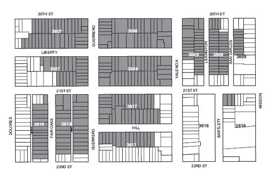
Map courtesy of San Francisco Planning Department