National Register of Historic Places in San Francisco
Central Embarcadero Piers Historic District
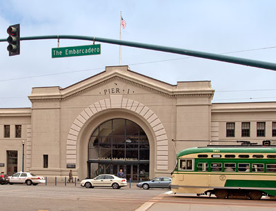
Piers 1-5
Built 1918-1931
In the last half of the 20th century San Francisco's waterfront was abandoned by the shipping trades and then cut off from the city by the elevated Embarcadero Freeway. With the removal of that multistoried throughway following the 1989 Loma Prieta Earthquake, the northeast waterfront district has developed into a district of varied maritime uses, offices and restaurants, gradually reweaving San Francisco to its shoreline.
Piers 1, 1½, 3 and 5, which are situated immediately north of the Ferry Building (NRHP Listing #78000760), comprise the southernmost grouping of Beaux-Arts piers built along the Embarcadero, a wide, busy thoroughfare that skirts the bay from Fisherman's Wharf on the north to China Basin on the south.
Excerpted from the NRHP nomination form.

The Central Embarcadero Piers Historic District is significant for its association with commerce and transport in San Francisco and its hinterlands. This was the only group of piers in the Port of San Francisco dedicated chiefly to inland trade and transport. These connections facilitated the growth of communities in the Sacramento and San Joaquin Valleys and helped to build an agricultural economy that, more than computers or movies, made California the richest state in the nation, with an economy that ranked fifth among world nations.
The piers also qualify for the National Register of Historic Places as one of the two largest remaining pier groupings along the Northeast Waterfront. Partially lost since containerization caused the obsolescence of the Northeast Waterfront, the near-continuous wall of Piers 1, 1½, and 3, with Pier 5 only narrowly separated, is still able to communicate the spirit of the grand Beaux Arts urban wall that once swept from the Ferry Building to Fisherman's Wharf, one of America's largest and most fully realized Beaux Arts designs.
Excerpted from the NRHP nomination form.
