Historic Sites and Points of Interest in Modoc County
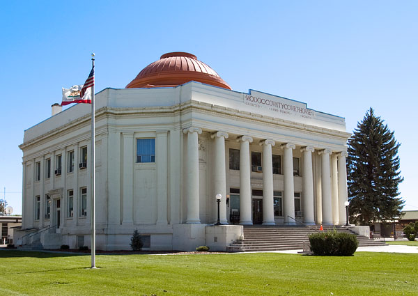 Modoc County Courthouse
Classical Revival Building Designed by Nevada Architect Frederick J. DeLongchamps
24 September 2006
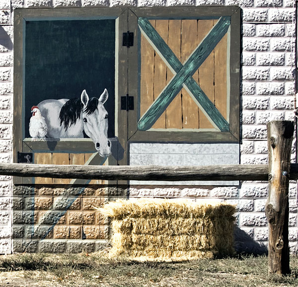 Old Paint Enjoys a Bale of Hay in Cedarville
24 September 2006
) Power to the People
Power to the People
State Route 139
17 October 2016
) State Route 139
State Route 139
17 October 2016
) Hay Shed on Clear Lake Road West of State Route 139
Hay Shed on Clear Lake Road West of State Route 139
17 October 2016
) County Road 54 Between Alturas and Canby
County Road 54 Between Alturas and Canby
17 October 2016
Modoc County is located in the northeast corner of California, bounded by Oregon to the north and Nevada to the east. The 2010 census counted 9,686 people. Alturas, the current county seat, is the only incorporated city in Modoc County.
A large portion of Modoc County is federal land. Several federal agencies, including the United States Forest Service, Bureau of Land Management, National Park Service, Bureau of Indian Affairs, and the United States Fish and Wildlife Service, have employees assigned to the area, and their operations are a significant part of the economy and services in this rural area.
| Name | Address | City | Year | Authority | ID | Sort Address | Sort Name |
|---|---|---|---|---|---|---|---|
| Adin Supply Company | Main Sreet | Adin | 1906 | National | 1997000028 | Main | Adin Supply Company |
| Applegate Trail 26A | County Road 18 | Applegate Trail | 1849 | POI | CR 018 | Applegate Trail 26A | |
| Applegate Trail 27 | County Road 15 | Applegate Trail | 1849 | POI | CR 015 | Applegate Trail 27 | |
| Applegate Trail 27A | County Road 15 | Applegate Trail | 1849 | POI | CR 015 | Applegate Trail 27A | |
| Applegate Trail 28 | Surprise Valley Road | Applegate Trail | 1849 | POI | Surprise | Applegate Trail 28 | |
| Applegate Trail 28A: Fandango Pass Asscent | Fandango Pass Road | Applegate Trail | 1849 | POI | Fandango Pass | Applegate Trail 28A: Fandango Pass Asscent | |
| Applegate Trail 28B: Fandango Pass Descent | Fandango Pass Road | Applegate Trail | 1849 | POI | Fandango Pass | Applegate Trail 28B: Fandango Pass Descent | |
| Applegate Trail 29 | Fandango Pass Road | Applegate Trail | 1849 | POI | Fandango Pass | Applegate Trail 29 | |
| Applegate Trail 30: Through the Forest | Forest Service Road 30 | Applegate Trail | 1849 | POI | FS 030 | Applegate Trail 30: Through the Forest | |
| Applegate Trail 31: Descent to Lassen Creek | County Road 133 | Applegate Trail | 1849 | POI | CR 133 | Applegate Trail 31: Descent to Lassen Creek | |
| Applegate Trail 32: Descent to Goose Lake | US 395 | Applegate Trail | 1849 | POI | US 395 30.30 | Applegate Trail 32: Descent to Goose Lake | |
| Applegate Trail 33: Davis Creek | Westside Road Near US 395 | Applegate Trail | 1849 | POI | Westside | Applegate Trail 33: Davis Creek | |
| Applegate Trail 34 | Near County Road 48 | Applegate Trail | POI | CR 048 | Applegate Trail 34 | ||
| Applegate Trail 35 | Near County Road 73 | Applegate Trail | POI | CR 073 | Applegate Trail 35 | ||
| Applegate Trail 36 | Near County Road 73 | Applegate Trail | POI | CR 073 | Applegate Trail 36 | ||
| Applegate Trail 37 | County Road 73 | Applegate Trail | POI | CR 073 | Applegate Trail 37 | ||
| Applegate Trail 38 | Near County Road 73 | Applegate Trail | POI | CR 073 | Applegate Trail 38 | ||
| Applegate Trail 39 | Forest Service Road 46 | Applegate Trail | POI | FS 046 | Applegate Trail 39 | ||
| Applegate Trail 40 | Forest Service Road 46 | Applegate Trail | POI | FS 046 | Applegate Trail 40 | ||
| Applegate Trail 41 | Steel Swamp Road | Applegate Trail | POI | Steele Swamp | Applegate Trail 41 | ||
| Applegate Trail 44: Bloody Point | Old Alturas Highway | Applegate Trail | POI | Old Alturas | Applegate Trail 44: Bloody Point | ||
| Applegate-Lassen Emigrant Trail | Fandango Pass Road | Fandango Pass | 1846 | California | 546 | Fandango Pass | Applegate-Lassen Emigrant Trail |
| Battle of Land's Ranch | State Route 139 and County Road 114 | Tulelake | 1872 | California | 108 | SR 139 | Battle of Land's Ranch |
| Bloody Point | County Road 104 West of County Road 114 | Tulelake | 1850 | California | 8 | CR 104 | Bloody Point |
| Bonner Grade | State Route 299 | Cedarville | 1869 | California | 15 | SR 299 | Bonner Grade |
| Burnett Cutoff | State Route 139 | Burnett Cutoff | 1848 | POI | SR 139 | Burnett Cutoff | |
| Burnett Cutoff 1: At Klamath Lake | Old Alturas Highway | Burnett Cutoff | 1848 | POI | Old Alturas | Burnett Cutoff 1: At Klamath Lake | |
| Burnett Cutoff 2: Muddy Water | Old Alturas Highway at State Route 139 | Burnett Cutoff | 1848 | POI | Old Alturas | Burnett Cutoff 2: Muddy Water | |
| Burnett Cutoff 3: Over a Prairie | State Route 139 | Burnett Cutoff | 1848 | POI | SR 139 | Burnett Cutoff 3: Over a Prairie | |
| Burnett Cutoff 4 | State Route 139 | Burnett Cutoff | POI | SR 139 | Burnett Cutoff 4 | ||
| Burnett Cutoff 5: Across Barren Ground | State Route 139 | Burnett Cutoff | 1848 | POI | SR 139 | Burnett Cutoff 5: Across Barren Ground | |
| Burnett Cutoff 6 | County Road 97 | Burnett Cutoff | POI | CR 097 | Burnett Cutoff 6 | ||
| Burnett Cutoff 7 | FS Road 44N68 | Burnett Cutoff | POI | FS 044 | Burnett Cutoff 7 | ||
| Burnett Cutoff 8 | State Route 139 | Burnett Cutoff | POI | SR 139 | Burnett Cutoff 8 | ||
| Burnett Cutoff 9 | Lookout Hackamore Road | Burnett Cutoff | POI | Lookout | Burnett Cutoff 9 | ||
| Burnett Cutoff 10 | Loveness Logging Road | Burnett Cutoff | POI | Loveness | Burnett Cutoff 10 | ||
| Burnett Cutoff 11 | Lookout Hackamore Road | Burnett Cutoff | POI | Lookout | Burnett Cutoff 11 | ||
| Burnett Cutoff 12 | Lookout Hackamore Road | Burnett Cutoff | POI | Lookout | Burnett Cutoff 12 | ||
| Burnett Cutoff 13 | County Road 85 | Burnett Cutoff | POI | CR 085 | Burnett Cutoff 13 | ||
| Canby's Cross Historic Marker | State Route 139 and County Road 120 | Newell | 1873 | California | 110 | SR 139 | Canby's Cross Historic Marker |
| Captain Jack's Stronghold Historic Marker | State Route 139 and County Road 120 | Newell | 1872 | California | 9 | SR 139 | Captain Jack's Stronghold Historic Marker |
| Chimney Rock | US 395 | Modoc County | 1870 | California | 109 | US 395 30.30 | Chimney Rock |
| Cressler and Bonner Trading Post | Center Street | Cedarville | 1865 | California | 14 | Center | Cressler and Bonner Trading Post |
| Davis Creek Community Church | Westside Road Near US 395 | Davis Creek | 1849 | POI | Westside | Davis Creek Community Church | |
| Evans and Bailey Fight | Centerville Road | Canby | 1861 | California | 125 | Centerville Road | Evans and Bailey Fight |
| Fort Bidwell | West End of Bridge Street | Fort Bidwell | 1863 | California | 430 | Bridge | Fort Bidwell |
| Frémont's Camp | County Road 114 North of State Route 139 | Tulelake | 1864 | California | 6 | CR 114 | Frémont's Camp |
| Infernal Caverns Batttleground | Ferry Ranch on County Road 60 | Likely | 1867 | California | 16 | CR 060 | Infernal Caverns Batttleground |
| Jess Valley Schoolhouse | County Road 64 (Jess Valley Road) | Likely | National | 1999000582 | CR 064 | Jess Valley Schoolhouse | |
| Lassen Trail 1 | Westside Road near US 395 | Davis Creek | 1849 | POI | Westside | Lassen Trail 1 | |
| Lassen Trail 2 | County Road 118 | Rural | POI | CR 118 | Lassen Trail 2 | ||
| Lassen Trail 3: Conical Rocks | US 395 | Rural | 1849 | POI | US 395 30.30 | Lassen Trail 3: Conical Rocks | |
| Lassen Trail 4 | Parker Creek Road | Dorris Reservoir | POI | Parker Creek | Lassen Trail 4 | ||
| Lassen Trail 5: Pit River Ford | 550 South Main Street | Alturas | 1849 | POI | Main S 0550 | Lassen Trail 5: Pit River Ford | |
| Lassen Trail 6 | County Road 257 | Rural | POI | CR 257 | Lassen Trail 6 | ||
| Lassen Trail 7 | County Road 179 | Rural | POI | CR 179 | Lassen Trail 7 | ||
| Lassen Trail 8: Rattlesnake Butte | County Road 54 | Rural | 1849 | POI | CR 054 | Lassen Trail 8: Rattlesnake Butte | |
| Lassen Trail 9: Pit River | Centerville Road | Canby | 1849 | POI | Centerville | Lassen Trail 9: Pit River | |
| Lassen Trail 10: Foot Wear | State Route 299/139 | Rural | 1849 | POI | 0299-010 | Lassen Trail 10: Foot Wear | |
| Lassen Trail 11 | Pit River Road near Turner Creek Road | Rural | 1849 | POI | Pit River | Lassen Trail 11 | |
| Lassen Trail 12 | County Road 85 | Rural | POI | CR 085 | Lassen Trail 12 | ||
| Lassen Trail 13 | County Road 85 | Rural | POI | CR 085 | Lassen Trail 13 | ||
| Lassen Trail 14 | Main Street | Lookout | POI | Main | Lassen Trail 14 | ||
| Nevada-California-Oregon Railway Depot | East and 3rd Streets | Alturas | 1908 | National | 1985000357 | East and 3rd Streets | Nevada-California-Oregon Railway Depot |
| Nevada-California-Oregon Railway Headquarters | 619 North Main Street | Alturas | 1917 | National | 1974000529 | Main 0619 | Nevada-California-Oregon Railway Headquarters |
| Old Emigrant Trail | Bushey Road | Modoc National Forest | 1849 | California | 111 | Bushey | Old Emigrant Trail |
| Sacred Heart Catholic Church | 507 East 4th Street | Alturas | 1883 | National | 1983001209 | Street 04 0507 | Sacred Heart Catholic Church |
| Tule Lake Relocation Center | State Route 139 and County Road 176 | Tulelake | California | 850 | SR 139 | Tule Lake Relocation Center | |
| Warm Springs Indians | State Route 139 near County Road 122 | Newell | 1873 | POI | SR 139 | Warm Springs Indians | |
| Willow Ranch | Willow Ranch Road and South Willow Ranch Road | Willow Ranch | 1929 | POI | Willow Ranch | Willow Ranch | |
| WWII Valor in the Pacific National Monument: Tule Lake Unit | County Road 176 near State Route 139 | Tulelake | 1942 | POI | CR 176 | WWII Valor in the Pacific National Monument: Tule Lake Unit |